
Earth's diverse landscapes significantly shape weather patterns. Topography influences air movement and moisture condensation, leading to varied precipitation rates. Mountain ranges act as barriers or channels for moisture, affecting rainfall on windward and leeward sides. Global climate change impacts precipitation distribution, complicating weather forecasting. Ocean proximity enhances rainfall through moisture exchange. Vegetation coverage influences cloud formation and precipitation dynamics. Climate change leads to extreme weather events like intense downpours and prolonged droughts. Microclimates create unique conditions across diverse landscapes, affecting temperature and rainfall distribution. Carbon dioxide levels intensify weather events, challenging predictions.
Precipitation patterns vary wildly across different landscapes, shaped by a complex interplay of natural forces. From towering mountain ranges to lush vegetation and ocean proximity, each element plays a unique role in dictating local weather conditions. Understanding these variations is key to deciphering global climate dynamics. This article explores how topography influences rainfall, the effects of oceans and vegetation, and delves into microclimates within diverse landscapes, shedding light on the intricate relationship between geographical features and weather patterns.
- Topography's Impact on Rainfall Patterns
- Mountain Ranges: Barriers or Channels for Moisture
- Ocean Proximity: Influence on Precipitation
- Vegetation Coverage and Land Cover Types
- Climate Changes' Effect on Regional Precipitation
- Local Microclimates within Diverse Landscapes
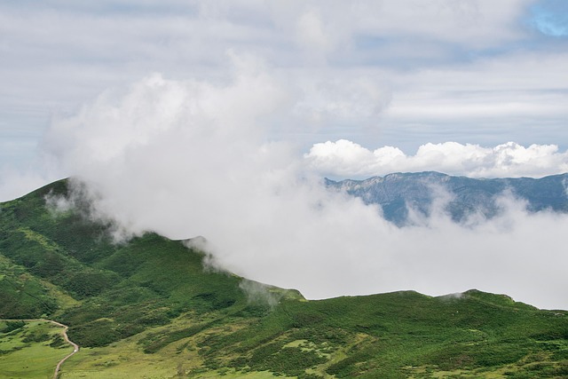
Topography's Impact on Rainfall Patterns

The Earth’s surface is diverse, boasting majestic mountains, vast plains, and sprawling oceans—each landscape playing a unique role in shaping local weather patterns, particularly rainfall. Topography, or the physical features of an area, significantly influences how much rain a region receives. When air masses encounter these landscapes, they are forced to rise, cool, and condense, leading to increased precipitation. For instance, mountain ranges act as barriers, causing moist air to ascend on the windward side, resulting in higher rainfall rates compared to leeward areas.
Wind gust calculations within these diverse terrains contribute to weather forecasting errors, highlighting the intricate relationship between topography and weather. The global climate change impact on these patterns is profound; rising temperatures and altered atmospheric circulation affect precipitation distribution worldwide. Notably, increased carbon dioxide levels play a role in intensifying weather events, further complicating rainfall predictions. For a deeper understanding of these dynamics, visit us at global warming impacts on weather anytime.
Mountain Ranges: Barriers or Channels for Moisture

Mountain ranges often act as barriers or channels for moisture moving across the landscape, significantly influencing local weather patterns. As air masses encounter these towering peaks, they are forced to rise, cooling and condensing as they do so. This process leads to increased precipitation on the windward side of the mountains, creating lush, verdant forests due to the abundant rainfall. On the leeward side, however, the air is dried out, resulting in drier conditions and sometimes even desert-like landscapes.
Understanding these dynamics is crucial for weather forecasting techniques, especially when predicting storms like hurricanes. The complex interactions between mountains and moisture can intensify or alter these weather systems, making accurate forecasting essential for hurricane preparation tips. Moreover, the global climate change impact on mountain ranges could further disrupt local weather patterns, affecting both natural ecosystems and human communities that rely on precise weather information, such as those available through visiting us at cyclonic storms explained anytime.
Ocean Proximity: Influence on Precipitation

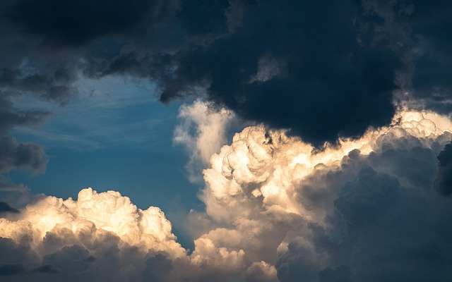
The ocean’s proximity significantly influences local weather patterns and precipitation across landscapes. Coastal areas often experience higher rainfall due to the continuous moisture exchange between the sea and air masses. Warm ocean currents, in particular, contribute to increased humidity, which leads to more frequent cloud formation and subsequent rain. As air moves over the water, it picks up moisture, creating a steady supply that supports robust weather systems.
This effect is closely tied to global wind patterns overview and atmospheric composition analysis, as winds carry this moist air inland, influencing cloud cover impacts evaporation processes. Moreover, proximity to vast bodies of water can prolong cloudy conditions and reduce sunlight intensity, which plays a role in the overall climate and precipitation dynamics of nearby landscapes. Find us at cloud formation for more insights into these intricate weather-related phenomena.
Vegetation Coverage and Land Cover Types
Vegetation coverage and land cover types play a significant role in shaping precipitation patterns across different landscapes. Areas with dense forests, for instance, tend to experience higher rainfall due to the canopy’s ability to capture and evaporate moisture, creating microclimates that foster more frequent and intense rain events. In contrast, arid regions with sparse vegetation are more susceptible to drought conditions, as sunlight absorption without plant transpiration results in increased surface heating, promoting evaporation and reducing available water for precipitation.
Furthermore, the interaction between vegetation and atmospheric composition analysis contributes to cloud erosion and dissipation processes. Forests influence air movement, which can lead to the formation of localized clouds that subsequently release precipitation. Conversely, areas with limited vegetation cover may experience faster wind speeds due to reduced friction, impacting cloud behavior and potentially exacerbating drought conditions, as seen in regions where global climate change impact has altered meteorological data collection and led to more severe weather events. Find us at drought conditions explained sunrise and sunset calculations can provide insights into these variations, highlighting the complex interplay between land cover, atmospheric processes, and weather patterns.
Climate Changes' Effect on Regional Precipitation
Climate changes play a pivotal role in shaping regional precipitation patterns across diverse landscapes. As global temperatures rise due to increasing greenhouse gas emissions, weather extremes become more prevalent. This leads to shifts in rainfall distribution, with some areas experiencing more intense and frequent downpours while others suffer from prolonged droughts. These alterations are not uniform; they vary based on geographical features, ocean currents, and the earth’s rotation influence, creating microclimates within larger regions.
For instance, coastal areas often benefit from the moisture-laden air brought by dawn and dusk phenomena, resulting in higher precipitation compared to inland regions. Conversely, desert landscapes typically have low humidity control strategies due to high evaporation rates and limited moisture retention, leading to arid conditions. Understanding these complexities is crucial for communities to adapt to changing weather patterns and implement effective humidity control strategies. To learn more about how these interactions affect local climates, find us at air mass interactions.
Local Microclimates within Diverse Landscapes
Local microclimates play a significant role in shaping precipitation patterns across diverse landscapes. Even within relatively close geographical locations, subtle variations in topography, vegetation, and water bodies can create unique weather conditions. For instance, areas with higher elevations often experience cooler temperatures and increased precipitation due to atmospheric instability causes, leading to more frequent rain or snow. Conversely, valleys and coastal regions might enjoy milder climates, with lower humidity levels affecting local rainfall.
These microclimates are not just about temperature and humidity; they also involve wind gust calculations weather forecasting errors, which can further influence the distribution of precipitation. Forests, for instance, tend to have higher moisture content in the air due to evapotranspiration from plants, potentially attracting more clouds and rain. In contrast, arid regions with sparse vegetation experience reduced atmospheric moisture, resulting in less frequent but often heavier rainfall events. Understanding these microclimates is essential for accurate weather forecasting, especially as factors like carbon dioxide levels contribute to broader climate patterns and seasonal weather changes, which we explore further on our platform.
Precipitation patterns across landscapes are shaped by a multitude of factors, from topography and mountain ranges to ocean proximity and vegetation cover. Understanding these variations is key to predicting weather events and managing water resources effectively. As climate change continues to alter global weather patterns, recognizing the unique microclimates within diverse landscapes becomes increasingly important for both ecological preservation and human adaptation.